

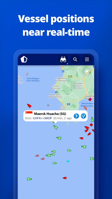
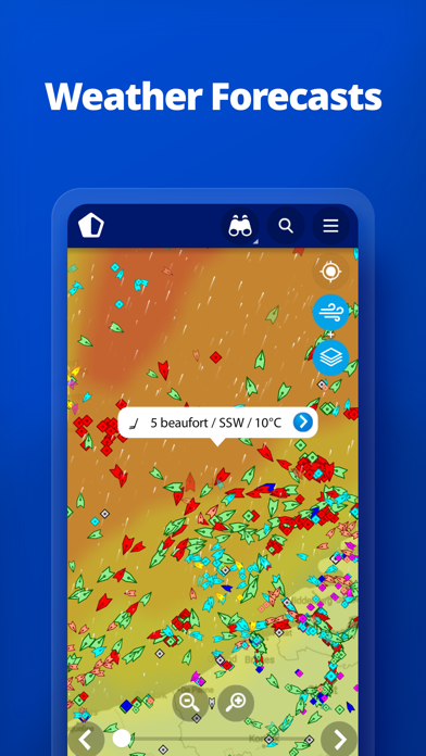
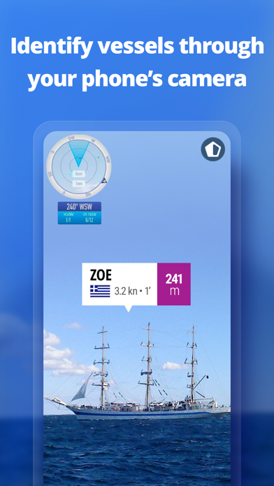
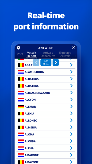
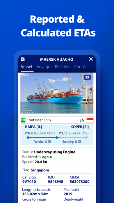
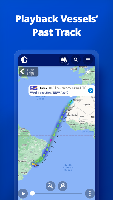

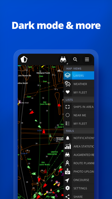
MarineTraffic displays near real-time positions of ships and yachts worldwide. Using the largest network of land-based AIS receivers, the app covers most major ports and shipping routes. • View VESSELS ON THE LIVE MAP, search for ships, boats and seaports and see what's near you! • More than 300,000 VESSELS PER DAY report their positions via MarineTraffic AIS • View live wind and 48-hour WIND FORECASTS on the map • ANIMATED PLAYBACK of vessel's track • PORT ARRIVALS & DEPARTURES live for over 4,000 ports and marinas, current conditions in ports and estimated time of arrival for the boats & ships. • Manage your list of vessels ("MY FLEET"), shared with all your devices and MarineTraffic.com • Browse 4.5 MILLION PHOTOS of ships, harbours, lighthouses and more! • Upload photos to MarineTraffic directly from your device. • Identify and track vessels sailing beyond the range of land-based AIS receiving stations, using satellite tracking, with ACCESS PLUS 24 (in-app purchase) • Identify vessels around you at a glance with the AUGMENTED REALITY tool Just point your device's camera to the horizon and get all the information you need about vessels, ports and lighthouses in your area: name, flag, speed, distance from you and a lot more. • Use the ROUTE PLANNER tool to plan a route on the map, measure distances and calculate ETA • MarineTraffic now offers auto-renewable subscriptions for Starter Plan, Nautical Charts, Weather Maps and Advanced Density Maps: Starter Plan - Unlock unlimited features like extended vessel and port details, vessel track, Advanced Search, Vessels near me, Augmented Reality and more Subscription name: Starter Plan Annual Cost: $9.99 (USD) Renewed every year i.e. you will be charged annually Get access to the marine environment with Nautical Maps - Pilotage information such as sea bed, sea marks and landmarks - Port details such as berths, dry docks and terminal location - Position and characteristics of buoys, lights, lighthouses - Depths of water and heights of land Subscription name: Nautical Charts Monthly Cost: $6.99 (USD) Renewed every month i.e. you will be charged monthly Subscription name: Nautical Charts Annual Cost: $66.99 (USD) Renewed every year i.e. you will be charged annually Unlock real-time & forecast weather information with Weather Maps - Wind contours - Wind flow & gusts - Temperature - Wave metrics - Clouds and Precipitation - Ocean currents - More than 20 key metrics - 7-days sea meteogram Subscription name: Weather Maps Layers Monthly Cost: $8.99 (USD) Renewed every month i.e. you will be charged monthly Subscription name: Weather Maps Layers Annual Cost: $95.99 (USD) Renewed every year i.e. you will be charged annually Advanced Density Maps - Dig into global shipping traffic data, filtering by vessel type. Subscription name: Advanced Density Maps Monthly Cost: $1.99 (USD) Renewed every month i.e. you will be charged monthly Subscription name: Advanced Density Maps Annual Cost: $17.99 (USD) Renewed every year i.e. you will be charged annually For all the above subscriptions: • Payment will be charged to iTunes Account at confirmation of purchase • Subscription automatically renews unless auto-renew is turned off at least 24-hours before the end of the current period • Account will be charged for renewal within 24-hours prior to the end of the current period, and identify the cost of the renewal • Subscriptions may be managed by the user and auto-renewal may be turned off by going to the user's Account Settings after purchase • Any unused portion of a free trial period, if offered, will be forfeited when the user purchases a subscription to that publication, where applicable Terms of Use: https://www.marinetraffic.com/en/p/terms Privacy Policy: http://www.marinetraffic.com/en/p/privacy-policy Join the great MarineTraffic community!
PC上で MarineTraffic - Ship Tracking のための互換性のあるAPKをダウンロードしてください
| ダウンロード | 開発者 | 評価 | スコア | 現在のバージョン | アダルトランキング |
|---|---|---|---|---|---|
| ↓ PC用のAPKをダウンロード | MarineTraffic.com | 6270 | 4.43206 | 4.1.24 | 4+ |
| SN | ソフトウェア | ダウンロード | 評価 | 開発者 |
|---|---|---|---|---|
| 1. | 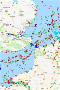 MarineTraffic MarineTraffic
|
다운로드 | 3.9/5 206 평가 |
Exmile Solutions Ltd |
あなたのWindowsコンピュータで MarineTraffic - Ship Tracking を使用するのは実際にはとても簡単ですが、このプロセスを初めてお使いの場合は、以下の手順に注意する必要があります。 これは、お使いのコンピュータ用のDesktop Appエミュレータをダウンロードしてインストールする必要があるためです。 以下の4つの簡単な手順で、MarineTraffic - Ship Tracking をコンピュータにダウンロードしてインストールすることができます:
エミュレータの重要性は、あなたのコンピュータにアンドロイド環境をエミュレートまたはイミテーションすることで、アンドロイドを実行する電話を購入することなくPCの快適さからアンドロイドアプリを簡単にインストールして実行できることです。 誰があなたは両方の世界を楽しむことができないと言いますか? まず、スペースの上にある犬の上に作られたエミュレータアプリをダウンロードすることができます。
A. Nox App または
B. Bluestacks App 。
個人的には、Bluestacksは非常に普及しているので、 "B"オプションをお勧めします。あなたがそれを使ってどんなトレブルに走っても、GoogleやBingで良い解決策を見つけることができます(lol).
Bluestacks.exeまたはNox.exeを正常にダウンロードした場合は、コンピュータの「ダウンロード」フォルダまたはダウンロードしたファイルを通常の場所に保存してください。
見つけたらクリックしてアプリケーションをインストールします。 それはあなたのPCでインストールプロセスを開始する必要があります。
[次へ]をクリックして、EULAライセンス契約に同意します。
アプリケーションをインストールするには画面の指示に従ってください。
上記を正しく行うと、ソフトウェアは正常にインストールされます。
これで、インストールしたエミュレータアプリケーションを開き、検索バーを見つけてください。 今度は MarineTraffic - Ship Tracking を検索バーに表示し、[検索]を押します。 あなたは簡単にアプリを表示します。 クリック MarineTraffic - Ship Trackingアプリケーションアイコン。 のウィンドウ。 MarineTraffic - Ship Tracking が開き、エミュレータソフトウェアにそのアプリケーションが表示されます。 インストールボタンを押すと、アプリケーションのダウンロードが開始されます。 今私達はすべて終わった。
次に、「すべてのアプリ」アイコンが表示されます。
をクリックすると、インストールされているすべてのアプリケーションを含むページが表示されます。
あなたは アイコンをクリックします。 それをクリックし、アプリケーションの使用を開始します。
MarineTraffic - Ship Tracking iTunes上で
| ダウンロード | 開発者 | 評価 | スコア | 現在のバージョン | アダルトランキング |
|---|---|---|---|---|---|
| ¥610 iTunes上で | MarineTraffic.com | 6270 | 4.43206 | 4.1.24 | 4+ |
why?
I have been using this App for a long time with no problem. but today, I was asked to purchase and could not see most of information. it says that I have 3/3 free /month. no information about what is each "1". time? number of vessels? can't understand whats going on. its useful where is my boyfriend now and whether he may or may not have an mobile connection. I need more information for purchase. Thanks.
まぁまぁ
細かい情報量は便利でありがたい 港から船を検索できるのも楽で良い ただ船の動静や更新の頻度で言えば無料のfindshipの方が上
ありがとうございます
AISデータを共有して頂いている方に感謝します。 これは任意でデータをUpしてくださる方のお陰で成り立っています。 相変わらずデータ共有の意味をわかっていないユーザーのコメントが多い感じがする。 データが無い地域ならAISの受信設備を整えて自ら共有されてみては如何でしょうか? このアプリやデータ共有の仕組みがよくわかるよ思いますよ。
Yes
Sometimes its delayed because i am stalking my hubby who is working in one of the tanker ship in Europe and i want to know if he is safe and im always looking him to get a signal. And this Traffic Apps is a big help if our loveones is travelling safe and the places they went too. I hope they will add more options like the internet connections. If there’s a signal connection too. It could be more helpful..
It gets worse with every update
I can't see the AIS signal of the China Coast Guard in marinetraffic though I can see it in other apps. why? In addition, narrowing down the ships has become troublesome.